Menu
Log in

australasian hydrographic Society

Log in


Search

Log in

News

  • 08 Nov 2019 08:47 | Admin (Administrator)


    On 27 August, the Australia-New Zealand Emergency Management Committee (ANZEMC) endorsed the National Framework for Flood Warning Infrastructure and the Flood Warning Infrastructure Standard developed by the National Flood Warning Infrastructure Working Group (the Working Group). The Framework provides guidance for future flood warning infrastructure planning and investment, based on jurisdictional analyses of their flood warning infrastructure. The Standard presents non-mandatory industry-recommended performance requirements for the design, development and monitoring of fit-for-purpose flood warning infrastructure. These initiatives will guide future flood warning infrastructure investments in an integrated and cost-efficient manner, to enhance flood warnings to the community. This marks the successful conclusion of the time-limited Working Group and is testimony to the collaborative nature of the Working Group and the hard work of all involved.

    Following Munro (2011) recommendations, ANZEMC established a Bureau of Meteorology Hazards Services Taskforce (the Taskforce) in October 2013. The Taskforce reported to ANZEMC in May 2015 and recommended the formation of the Working Group. The Working Group was established in 2016 to address the limitations and inconsistencies of flood infrastructure and standards across Australia. The Working Group involved extensive collaboration and inter-agency cooperation to standardise national flood warning services and infrastructure; an ambitious undertaking given the wide variety of climates, jurisdictions, and agencies involved. The Working Group was a time-limited project, working to deliver a Flood Warning Infrastructure Standard, Infrastructure reports for each jurisdiction, and a National Framework for Flood Warning Infrastructure by 2019. The Working Group produced these deliverables within the specified timeframe.


    Chairs of the ANZEMC

    Collaboration was key to the success of the Working Group. In accordance with the Total Flood Warning System, flood warnings in Australia are provided via a partnership involving all levels of government: Commonwealth, State, Territory and local. While the Bureau of Meteorology has the responsibility for the provision of forecasting and warning services for riverine flooding in all states and territories (with limited exceptions), the prime responsibility for flash flood warnings lies with states and territories in partnership with local government. However, the Bureau provides forecasts and warnings for severe weather conditions and potential heavy rainfall conducive to flash flooding. Given the already inter-dependent nature of these relationships, the Working Group demonstrated the significance of a cooperative spirit to improve the preparedness and safety of the community.

    Consultation: Flood Warning Infrastructure Standard


  • 24 Aug 2019 07:43 | NZR Chair (Administrator)

    This Webinar will cover Certification topics for Hydrographic Surveying and deployment of Tide Gauges for the single datum project in NZ

    The details of this Webinar and how to log in are in the attached file

    Webinar 2019 Professional Certification and JLAS Tide Gauges.pdf

    29 Sept 2019: the recording is available here   


  • 29 Mar 2019 12:33 | NZR Chair (Administrator)

    This webinar explains the LINZ's project for a single land/marine datum and an experience with a terrestial scanner on a hydrographic boat.

    The login details are here PDF 

    The 1 hour recorded session is here for downloading and viewing.


  • 12 Feb 2019 14:11 | NZR Chair (Administrator)

    The AHS & SSSI awards were presented to the recipients during the HYDRO18 dinner. The AHS Awards were presented by Steve Duffield, President and the SSSI Award was presented by Richard Cullen. The awards for the NZ contingent are as follows:

    Dr Helen Neil, NIWA

    The Society’s Award of Merit for Scientific and Technological Achievement – Scientific Achievement by an Individual. A career marked by excellence and achievement in scientific endeavour and services.

    Kevin Mackay, NIWA

    The Society’s Award of Merit for Scientific and Technological Achievement – Scientific Achievement by an Individual. A career marked by excellence and achievement in scientific endeavour and services.

    Greg Cox, Discovery Marine

    The Society’s Award of Merit for Career Achievement in Hydrography. A career marked by excellence and achievement at the national level in hydrographic surveying and services.

    Dave Field, iXBlue

    The SSSI Hydrography Commission award for services to the AHSCP Panel.


  • 21 Sep 2018 16:00 | NZR Chair (Administrator)
    4pm NZ time. Speaker is from Swire Seabed (Norway)

    for details on the topic and how to log in to view and listen click here

    The presentation (PDF) is now available for download by clicking here


  • 17 Sep 2018 14:36 | NZR Chair (Administrator)
    This year, the Hydrography Professional Stream (HPS) ran a successful one-day event as part of the annual NZ Institute of Surveyors (NZIS) Conference. It was supported by the NZIS organising committee and representatives from the New Zealand hydrographic industry.

    Three university students were generously sponsored by the Australasian Hydrographic Society (AHS) and the New Zealand Region of the AHS and to attend and report on the day.

    Please enjoy reading the students excellent report from the event, from page 21... https://www.surveyors.org.nz/Article?Action=View&Article_id=107

    Some of the presenters have allowed their presentations to be made public so please contact Gary Chisholm (NZR, gary_chisholm@trimble.com ) if you would like to view them.


  • 24 Aug 2017 14:20 | Admin (Administrator)


    The Alexander Dalrymple Award has been awarded to Mr Adam Greenland, National Hydrographer, Land Information New Zealand

    The Alexander Dalrymple Award is given by the United Kingdom Hydrographic Office (UKHO) in recognition of an outstanding contribution to world hydrography. First presented in 2006, it is named in honour of the first Hydrographer of the Royal Navy in 1795.

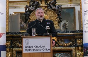
    The Award was presented at reception in London by Rear Admiral Tim Lowe, UK National Hydrographer and Deputy Chief Executive of the UKHO. Admiral Lowe commented:

    “Adam has made a significant contribution to capacity building and improving maritime safety in the Southwest Pacific region. As National Hydrographer, he has a wide ranging and busy portfolio from managing a very efficient national and regional production/delivery unit through to representing New Zealand at a variety of strategic fora within the International Hydrographic Organization (IHO).

    “He is also a member of the New Zealand Geographic Board (NZGB) and a hugely active Capacity Building Coordinator for the South West Pacific Hydrographic Commission (SWPHC). In the latter, he has delivered significant training and mentoring initiatives in areas such as maritime safety information, hydrographic surveying training and nautical cartography training. These aspects have significantly benefitted developing Member States across the breadth of an enormous sea area.”

    Adam Greenland is the twelfth recipient of the Alexander Dalrymple Award. Educated at the University of East London and the University of Greenwich, and a former Merchant Mariner, Adam Greenland is a Chartered Surveyor who has been with Land Information New Zealand (LINZ) since 2005.

    In making the presentation, Admiral Lowe commended Mr Greenland’s leading contribution towards New Zealand’s fulfillment of its SOLAS (Safety of Life at Sea) responsibilities, his work as a member of the IHO/FIG/ICA International Board of Standards of Competence, setting and reviewing the minimum international standards of competence for hydrographic surveyors and nautical cartographers, and his role as a driving force in the Pacific Region Navigation Initiative (PRNI). This initiative is focused on navigation related aspects of maritime safety to support Pacific Island Countries fulfill their own SOLAS obligations.

    The award presentation took place at a reception held at Lancaster House in London to mark the UK Government’s celebration of World Hydrography Day 2017, a United Nations-endorsed recognition of the vital role of hydrography in supporting safe navigation and sustainable use of the world’s seas, oceans and waterways.

    The theme chosen by the IHO for this year’s World Hydrography Day is ‘Mapping our seas, oceans and waterways - more important than ever’ and Admiral Lowe spoke of the relevance of this theme to the work of the UKHO:

    “This year’s World Hydrography Day theme has tremendous synergy with the work we undertake at the UKHO on a daily business and with Government initiatives designed to aid the development of sustainable marine economic growth, nationally as well as worldwide. Our knowledge of the shape, nature and depth of the seafloor is a fundamental requirement for the proper, safe, sustainable and cost effective use of the world’s seas, oceans and waterways.”

    Admiral Lowe also paid tribute to the work of the IHO’s long-serving former President and current General Secretary, Robert Ward, who is due to step down from the role later this year. Admiral Lowe said:

    “Robert has a long history of involvement in the implementation and development of the standards and regulations associated with electronic chart navigation and digital hydrographic data, both in the IHO and in the IMO. On behalf of the United Kingdom and the UKHO, we would like to thank Robert for his valuable contribution to the work of the International Hydrographic Community during his Presidency and latterly, as General Secretary of the IHO.”


  • 20 Aug 2017 08:24 | NZR Chair (Administrator)

    This Webinar is proudly sponsored By Trimble.

    When:
    Monday 11th September 8pm NZ time, 6pm NSW/VIC time, 9am UK
    • Duration: 1 hour
    • It will be recorded for members who can’t make the date/time

    Agenda:

    • Opening remarks: Gary Chisholm & Kevin Smith (NZR Chairman)

    • Understanding shallow water multibeam systems
            o    Pim Kuus - Teledyne Reson , UK
            Technical details to consider for shallow water (<50m) precise surveying with multibeam
            Mounting considerations
            Understanding of accuracies in the multibeam and the
    positioning and attitude sensor required
            Determine what PC processing can be reduced for a faster
    turnaround from boat time to electronic surface


    Accessing the Webinar:

    Visuals: Visuals are available from the GoToMeeting service facilitated by
    Trimble as follows:
    https://global.gotomeeting.com/join/768296557
    Access Code: 768-296-557
    Audio is available by phone as follows:
    • NZ Free Phone: 0800 14 1485
    • Australia Free Phone: 1800 191 358
    • UK Phone: +44 330 221 0097

    Notes:
    • As the webinar system might require a download, please take time in advance of the webinar to log
    in to the link using the same PC you will utilize for the webinar. This may take a few minutes to
    complete.
    • The webinar will not be live until the moderator starts it a few minutes before the planned time.
    • It is only intended to utilise the webinar tool for visuals, therefore do not select the webinar
    videoconference or audio service. Use the phone for audio.
    • Once you have phoned in to the audio service please mute your phone. If there is too much
    background noise the moderator will have to put everyone on mute.
    • Trimble will not be able to provide IT support during the webinar.
    Point of Contact Details:
    Gary Chisholm
    Email: gary.chisholm@trimble.co.nz

  • 11 Jul 2017 08:15 | NZR Chair (Administrator)

    World Hydrography Day 2017 - New Zealand Seminar

    When: Thursday 6th July 2017

    Where: Otago University, New Zealand

    It was a very well attended and stimulating day. Here are four presentations, and there will be others coming later.

    Choosing A Bathymetric System

    Kaikoura Recovery Surveys

    Joining Land and Sea Datums

    Freshwater Multibeam


  • 27 Jan 2017 08:48 | Admin (Administrator)


    The beginning of 2017 commenced with a well attended event on 19th January with three presentations by Edgetech and Acoustic Imaging. 

    Presenters From EdgeTech and Acoustic Imaging organized to present on acoustic and supporting sensor developments including:

    • EdgeTech’s 6205 - increases efficiency and safety for shallow water surveys; Evan Martzial presented on EdgeTech’s Multi Phase Echo Sounder System
    • Shallow water multibeam echo sounders - case study of R2Sonic dual head 2020 by Doug Bergersen
    • GNSS Inertial Positioning in Australia - latest tools and technology developed by Applanix including PP RTX presented by Nicole Bergersen presenting

Recent News

We Pursue Excellence, Accuracy, Freedom of Information, People, Technology and Safety under a Non-Profit Society ...

Would like to Join Us?

Join us

Powered by Wild Apricot Membership Software